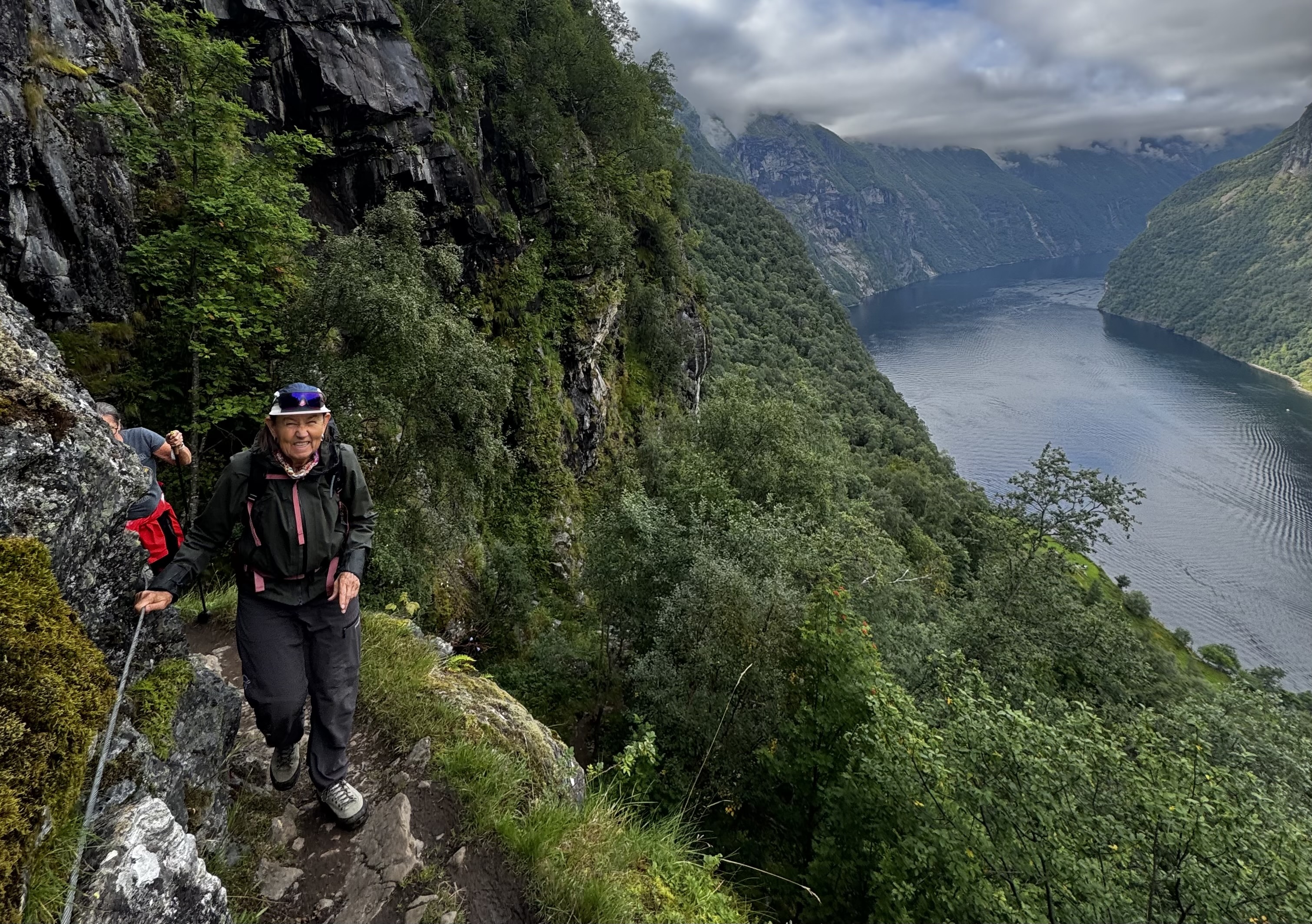
The best hike in Geiranger is Skageflå, a historic mountain farm high above the Geirangerfjord with views across to the Seven Sisters waterfall. Storseterfossen, where you walk behind a waterfall, and the Løsta viewpoint are the best shorter options. Both start at Vesterås farm just above the village. Gråsteindalen, Gomsdalen and Laushornet suit experienced hikers.
Best Hikes in Geiranger (2026) – Top Trails, Views & Skageflå
Geiranger is one of Norway’s most spectacular hiking destinations. Steep mountains rise straight from the fjord, so even short hikes can give you world-class views.
This guide covers the best hikes in Geiranger, from iconic trails like Skageflå to short viewpoint walks and quieter mountain routes for experienced hikers. You will also find a comparison table, practical information on start points and parking, and ideas for hiking near Geiranger.
See all the tours we offer in Geiranger here
Geiranger hikes at a glance
The figures below are approximate. Conditions, snow and route choice can change times considerably. Always check local trail signs and the weather before you set off.
| Hike | Start point | Distance (return) | Ascent | Time (return) | Difficulty |
|---|---|---|---|---|---|
| Løsta viewpoint | Vesterås farm | approx. 2 km | approx. 200 m | 1–1.5 h | Moderate |
| Storseterfossen | Vesterås farm | approx. 4 km | approx. 300 m | 2–3 h | Easy to moderate |
| Vesterås–Storseterfossen–Løsta | Vesterås farm | approx. 6 km | approx. 400 m | 3–4 h | Moderate |
| Skageflå from Skagehola | Skagehola (boat access only) | approx. 2 km | approx. 250 m | 1.5–2 h | Moderate to demanding |
| Skageflå from Homlong | Homlong | approx. 10 km | approx. 400 m | 4–5 h | Moderate to demanding |
| Homlongsætra | Homlong | approx. 4 km | approx. 300 m | 2–3 h | Moderate |
| Flydalsjuvet | Viewpoint on the road towards Dalsnibba | Short walk | Minimal | 15–30 min | Easy |
| Dalsnibba area | Dalsnibba mountain road | Varies | Varies | 1–3 h | Easy to moderate |
| Gråsteindalen / Gomsdalen | Mountain valleys above Geiranger | Varies | Varies | Half to full day | Moderate to demanding |
| Laushornet | Above Geiranger village | Long | Significant | Full day | Demanding |
The #1 hike in Geiranger: Skageflå
The Skageflå hike from Skagehola is one of the most iconic hiking experiences in Geiranger. The route climbs from the fjord shoreline to the historic mountain farm of Skageflå, perched high above the UNESCO-listed Geirangerfjord.
It is a true fjord adventure, with steep cliffs, dramatic scenery and one of Norway’s most famous viewpoints. From the farm you look straight across the fjord to the Seven Sisters waterfall.
Skagehola can only be reached by boat. That is why many hikers combine the climb with a fjord transfer. Our Skageflå Hike & RIB Adventure takes about six hours and includes lunch. The minimum age is 13.
You can also reach Skageflå on foot from Homlong, which is accessible by road from Geiranger. This is a longer route along the hillside, and many hikers like to walk one way and take a boat the other. The path down to Skagehola is steep and exposed in places, so take care, especially in wet conditions.
Read our full route guide to hiking to Skageflå here, or learn more about the guided Skageflå tour.
Best hikes around Geirangerfjord for cruise visitors (short time)
If you only have a few hours, choose hikes that start close to the village and reward you with views quickly. Both of the hikes below start at Vesterås farm, just above Geiranger village. It is a short drive from the harbour. You can also walk up from the village if you want a longer outing. For more ideas for a port day, read our guide to what to do on a Geiranger cruise stop.
Løsta viewpoint
The Løsta hike is one of the best short hikes in Geiranger if you want spectacular fjord views without committing to a full-day mountain trek. The trail climbs steadily from Vesterås to a viewpoint overlooking the Geirangerfjord.
At the top, you can see:
- The Geirangerfjord
- The winding Ørnevegen (Eagle Road)
- Cruise ships far below in the fjord
- Steep mountains rising dramatically from the water
Compared with the busy viewpoints you can drive to, Løsta feels peaceful and more authentic, and you truly earn the view. The hike also pairs well with a paddle on the fjord. See our guide to kayaking in Geiranger or join a guided fjord kayak tour.
Storseterfossen – walk behind the waterfall
The Storseterfossen hike is one of the most popular hikes in Geiranger. What makes it special is that you walk behind the waterfall and feel the power of the water from inside the rock face. From Vesterås, a well-marked trail climbs through forest and mountain terrain to the falls.
- Walk behind the waterfall
- Excellent photo opportunities
- Views of the Geirangerfjord on the way up
- The dramatic sound and mist of the falling water
On sunny days, you may see rainbows in the spray. The rocks near the waterfall are often wet and slippery, so wear shoes with good grip.
Combining Vesterås, Storseterfossen and Løsta
If you have a little more time, you can combine Storseterfossen and Løsta into one outing from Vesterås farm. This gives you a waterfall and a fjord viewpoint in half a day. Ask locally or check the trail signs for the current route.
Best hikes for hotel guests (1–3 nights)
If you stay a few nights, you can go beyond the famous viewpoints and explore the quieter mountains above the fjord.
Gråsteindalen and Gomsdalen
Gråsteindalen and Gomsdalen offer a quieter, more alpine experience. You will find open terrain, mountain lakes, dramatic peaks and a real sense of wilderness, often without meeting many other hikers. The routes are longer and less marked than the trails from Vesterås, so they suit hikers with some mountain experience, good footwear and a map. Snow can remain in these valleys well into early summer.
Read more about hiking in Gråsteindalen and Gomsdalen.
Homlongsætra
From Homlong, a path climbs to the summer farm at Homlongsætra. This is a quieter alternative with fine views over the outer part of the Geirangerfjord, and it combines naturally with a visit to Skageflå.
Laushornet
Laushornet is a demanding summit hike above Geiranger village for fit and experienced hikers. The reward is a big view over the fjord and the surrounding mountains. Choose a day with stable weather, start early, and get up-to-date route information before you go.
Flydalsjuvet and the Dalsnibba area
Flydalsjuvet is the classic viewpoint above Geiranger, located on the road towards Dalsnibba. A short walk takes you to the famous view down to the village and the fjord. Higher up, the Dalsnibba area offers easy walks in open mountain terrain with views over the whole valley. Snow can linger here until well into the summer.
Want to see more of the area on two wheels? Our E-bike and hike in Geiranger combines cycling and walking. For other activities, read the best things to do in Geiranger.
Hiking near Geiranger
Geiranger is a great base for exploring the wider Sunnmøre region. These hikes are within reach of Geiranger by car or ferry:
- Hellesylt – a quieter fjord village at the other end of the Geirangerfjord. See things to do in Hellesylt.
- Valldal – home to the summit hike Mefjellet and the shorter Ruggå viewpoint. See all activities in Valldal.
- Stranda – try the e-bike and hike to Lievarden above the Storfjord. See more in Stranda.
- Hjørundfjorden – alpine peaks straight from the fjord. Read our guide to the Slogen hike from Øye.
- Åndalsnes – the famous ridge walk Romsdalseggen, which you can also do as a guided hike.
Staying in Ålesund? Read about fjord tours from Ålesund, or see all our guided hikes.
Getting to the trailheads: parking and transport
Vesterås farm is the starting point for Løsta and Storseterfossen. You can reach it by car or on foot from the village, and there is parking at the farm. Homlong can be reached by road, but parking there is limited. Skagehola is accessible only by boat. Flydalsjuvet and the Dalsnibba area lie along the mountain road south of the village.
Public transport to the trailheads is limited, so plan your trip in advance if you do not have a car. A guided tour with transport included is often the simplest option.
Guided hiking vs hiking alone
Many trails in Geiranger are well marked and can be done on your own. A guide brings local route knowledge, safety and a deeper understanding of the nature and history of the fjord farms. This is especially valuable in mountain terrain, where the weather changes quickly, and on steep routes like Skageflå. We also offer private guided hikes for families and groups. Read more about how we work with safety.
Frequently asked questions
What is the best hike in Geiranger?
Skageflå is widely considered the most iconic hike in Geiranger. This historic mountain farm sits high above the Geirangerfjord and looks straight across to the Seven Sisters waterfall. Storseterfossen, where you walk behind the waterfall, and the Løsta viewpoint are the most popular shorter hikes.
Do you need a guide for hiking in Geiranger?
Not always. Many trails are well marked and can be done on your own. A guided hike is recommended if you want the safest route choice for the weather and trail conditions, if you plan to hike Skageflå (steep and exposed in places, and reached by boat from Skagehola), if you are on a cruise stop with limited time, or if you want local knowledge about history and nature.
How difficult are hikes in Geiranger?
Geiranger has hikes for different fitness levels. Flydalsjuvet is easy, Storseterfossen is easy to moderate, Løsta is moderate, and Skageflå is moderate to demanding. Gråsteindalen, Gomsdalen and Laushornet are for experienced hikers. Even short hikes can feel demanding because many trails climb steeply.
What is the best hike for cruise guests in Geiranger?
Storseterfossen and Løsta are the best short options. Both start at Vesterås farm just above the village. If you have more time, the Skageflå hike combined with a fjord transfer is unforgettable but needs planning. Always check your ship’s all-aboard time and allow a generous buffer, for example 45–60 minutes, before departure.
When is the best season for hiking in Geiranger?
The main hiking season usually runs from late spring to early autumn, depending on how much snow is left. Lower trails such as Storseterfossen and Løsta open first, while higher areas like Dalsnibba, Gråsteindalen and Laushornet can hold snow into early summer. Mid-summer often has the most stable weather, while early and late summer are usually quieter.
Where do I park, and is there a map of the hiking trails?
For Løsta and Storseterfossen, park at Vesterås farm above the village. For Skageflå on foot and Homlongsætra, start at Homlong, where parking is limited. Trails near the village are signposted. Bring a hiking map or use a map app with offline maps for longer routes such as Gråsteindalen, Gomsdalen and Laushornet.
Can I reach the trailheads by public transport?
Public transport to the trailheads is limited. You can walk to Vesterås farm from the village if you want a longer hike. Skagehola can only be reached by boat. A guided tour with transport included is often the easiest option.
What should I wear for hiking in Geiranger?
The weather can change quickly in the fjords, even in summer. Wear sturdy hiking shoes with good grip and dress in layers, including a warm wool or fleece mid-layer and a windproof, waterproof jacket. Bring water, a snack, sunscreen and sunglasses.